 English
  Español
 Phase 1 Season 1
Easter Island Statue Project Conservation Initiative Preliminary Report March-April, 2010
Introduction
This project is the first controlled, scientific archaeological excavations ever undertaken in the interior of Rano Raraku Quarry. It is also the first stone conservation and preservation pilot program in Rano Raraku.
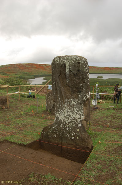
All but one of the 22 standing statues (moai) in Rano Raraku Quarry interior have been previously exposed through unscientific and undocumented digging. The Target Statues for this project (RR-001-156 and RR-001-157) have been dug or otherwise disturbed by the Mana Expedition (1914), the Franco-Belgian Expedition (1935), and the Norwegian Archaeological Expedition (1954-55).
The Easter Island Statue Project (EISP) has a 20 year history of archaeological survey on Easter Island (Rapa Nui), the objective of which is the creation of a full and complete, island-wide monolithic and portable statue inventory and the compilation of an historical image record for each statue. Prior to the selection of Quarry Two for the excavations described here, the EISP team completed a five year mapping foray in the interior of Rano Raraku, the volcanic quarry from which 95 percent of the extant monolithic sculpture were produced (Van Tilburg 1994; Van Tilburg, Arévalo Pakarati and Alice Hom 2008).
- We achieved the complete mapping of all archaeological features in the interior to cm level accuracy. We then supplemented the survey record to that date for the previously mapped exterior sector (Cristino et al. 1981).
- Secondly, we compiled complete visual and above-ground metric records on every statue in the entire Rano Raraku Quarry.
- Thirdly, we integrated these data into our digitized record for 1445 statue object records.
- Finally, we established the EISP DATASHARE on-line database accessible to our collaborators and to Chilean agencies.
The result of this work is a full and complete preliminary study of each statue, its precise location and site context and, finally, its entire extant excavation record. As a consequence of this preliminary work, we selected Statues RR-001-156 and RR-001-157 in Rano Raraku Quarry interior for excavation. Our goal was to initiate a pilot conservation study.
Project Participants
Jo Anne Van Tilburg, Ph.D.
Cristián Arévalo Pakarati
Christian Fischer, Ph.D.
Mónica Bahamondez Prieto
Alice Hom
Paula Valenzuela
Field Crew
Patricio Rodrigo Madariago Paoa
Benjamin Mihaore Pakarati González
Carlos E. Rapu Rapu
Log of Phase 1 Activities
Quarry Two: Excavation Tools, Equipment, and Site Preparation Procedure
The field office for this project is maintained at the EISP office in the Mana Gallery, Petero Atamu s/n, Hanga Roa, Rapa Nui, Chile. All mechanical wood and metal cutting, shaping tools and excavation equipment is provided on-site by EISP.
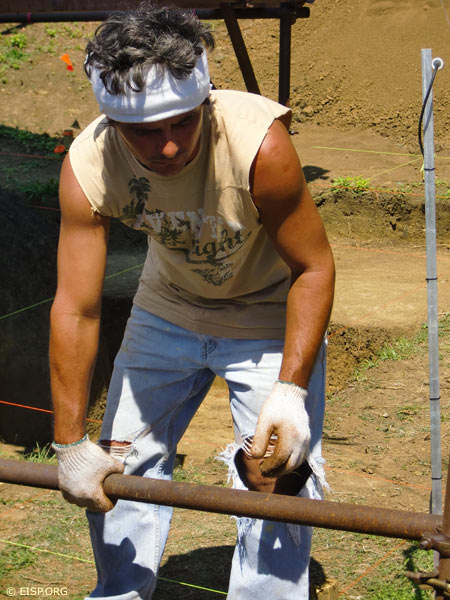
Quarry Two was first cleared of vegetation and grass by our team of four: Jo Anne Van Tilburg, Cristián Arévalo Pakarati, Johannes Van Tilburg and Patricio Rodrigo Madariaga Paoa. This work took nearly three days. The grass on the top portion of Quarry Two (containing carving canals but no statues) was cut with mechanical tools by a team employed by CONAF. Vegetation and some debris was removed to the northwest portion of the site outside of the fence and stored there. We cut a pathway facilitating tourist visits through the vegetation just outside the fence and below the previously existing trail. Tourists used this trail with no problems.
A protective wood fence was built to cordon off the site and assure that none of the many horses that roam freely in Rano Raraku will enter. It is made of pine poles 248 cm long and 8 cm in diameter. Seventeen post holes were dug to a uniform 60 cm deep. The posts were numbered. In three cases, stone carving tools called toki were found in post holes (numbered 2, 15 and 16, respectively). These were collected, numbered by writing in black ink on removable blue painters’ tape and then measured, photographed, and stored in a plastic bin. At the end of the first few days we had recovered a total of 10 toki. We anticipate finding dozens more of such tools.
Archaeological Collections
The Padre Sebastián Englert Museum of Archaeology and Anthropology on the island has ultimate responsibility for all archeological collections. All materials will be washed, weighed, photographed, measured, bagged and described in the Mana Gallery lab and then deposited at the museum.
Photographic Documentation
A full and complete photographic record of the excavations and the objects retrieved as well as the conservation work being implemented is collected, edited and stored in the EISP image database. Overviews of Quarry Two and each statue prior to excavation were taken. A first-hour and last-hour photograph is taken each day. Photos are made of each level attained in each square. The time of day is noted especially as it has meaning in terms of the visible color and apparent moisture content of the stone surface as it is uncovered. Video or film documentation of this project will take place on an on-going basis.
Quarry Two: Area Excavation Grid
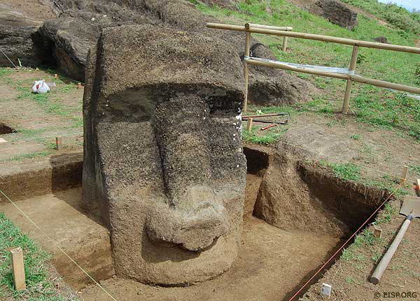
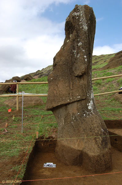
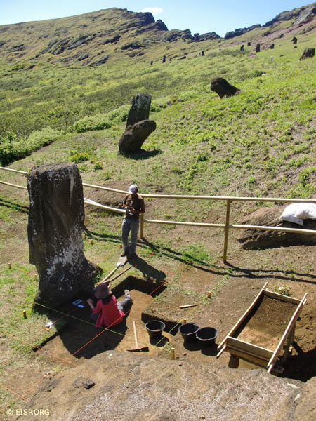
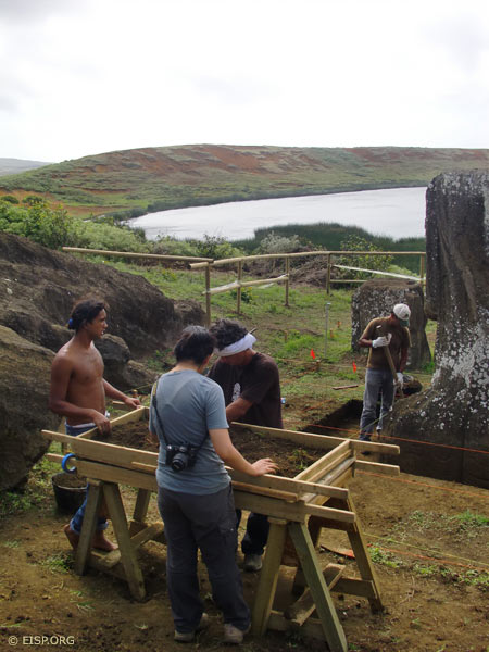
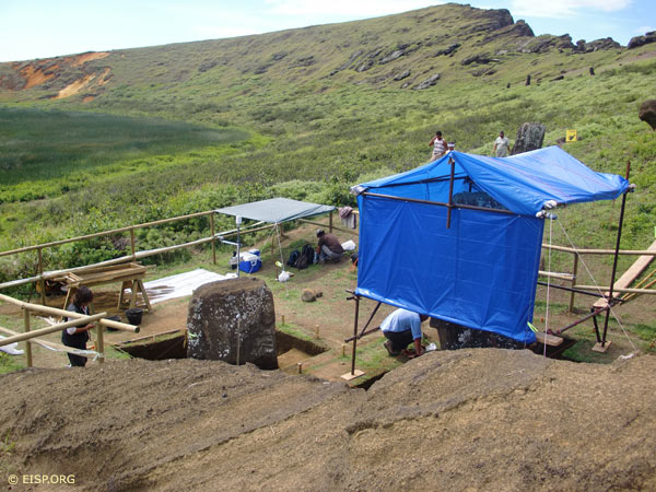
A preliminary grid was created in the EISP lab prior to the initiation of field work. The site was first quartered and then the preliminary grid was edited and adapted in the field. It consists of a space 10 m long by 6 meters wide. The grid accommodates evident bedrock at the west side of the site as well as the need to leave a tourist path open on the north end of the site. The ground to the north also drops off quite rapidly. The entire area is divided into sections for each of the two target statues being excavated (Statue 156 and Statue 157). The squares associated with each statue are referred to as Unit 156 and Unit 157, respectively. Unit 156 has 12 one meter squares numbered consecutively from the northwest corner grid stake at the lower portion of the cleared site. Unit 157 has 19 squares numbered consecutively. Unit 156 has 12 consecutively numbered squares. The datum was established by compass and the grid will be surveyed in to cm level accuracy and integrated into our map. Elevation 0 Datum is the southeast corner stake of Unit 157, square 19. The slope decreases to elevation -73 m at the northeast corner grid stake and elevation – 94 m at the northwest corner grid stake. The southwest corner grid stake marks elevation -23 m.
Quarry Two: Historic Level Book
Sections depicting the preliminary excavation plan from the existing grade to -3 m depth for Statue 157 and -4m depth for Statue 156 were created on the altered grid and in accordance with the information analyzed in our photographic level book. We assume that the images in the level book truly reflect the soil level changes from 1914 to the present.
Excavation and Screening of Deposits
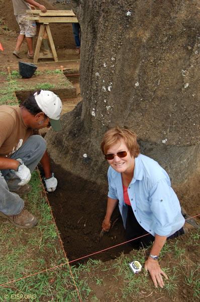
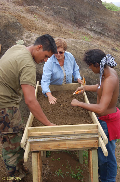
The initial excavations within the open grid layout are impacted by the overburden at the back of Quarry Two and at the dorsal side of each statue. This overburden is extensive and nearly sterile. Nonetheless, we commenced screening using buckets to remove soil to a sorting board which we built on site. The first level of the sorting board consisted of a 3/16” screen on one half and a plywood platform on the other. This successfully allowed the examination and removal of large stones and heavy vegetation remains prior to moving the rest of the deposit over on to the screen for processing. The lower level of the platform consisted of 1/8” screen. Deposits in squares more distant from the statue were removed with a square head shovel. Those closest to the statue were removed with a trowel or, at times, even smaller tools. The stone surface of the statue was brushed after exposure to remove damp or clinging earth, small roots, seeds and other plant and insect remnants.
Backdirt
The calculated amount of backdirt that will accumulate on the site is substantial and makes proper handling of this material a crucial issue from the inception of the project. Our initial plan was to remove the overburden at the back of Quarry Two and store it in sandbags that would, in turn, be used to protect the site from downwash from the slope above during rains. However, no proper bags are available on the island, and some will have to be either ordered from the mainland or brought from California. For this phase of the work we will remove the backdirt from Unit 157 to the southwest corner of Quarry Two inside of the fence. That from Unit 156 will be screened inside the fence over a plastic tarp and then removed to the northwest portion of the site outside of the fence and on the other side of the tourist path.
Environmental Monitoring, Data Analysis, and Conservation
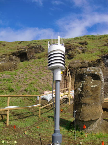
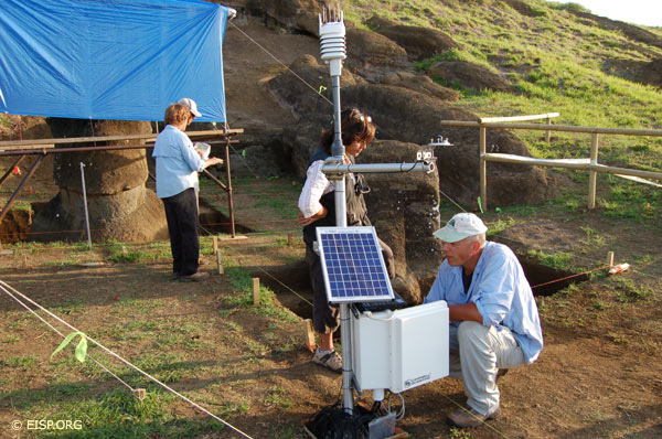
We opened a 35 x 35 x 45 cm deep square within the fenced area but outside of the grid and poured concrete to establish a base for the installation of the Environmental Monitoring Station that is part of the conservation aspect of this project being directed by Christian Fischer, conservation scientist and Research Association, UCLA, and Mónica Bahamondez Prieto, Centro de Conservación y Restauración, Santiago de Chile.
The environmental monitoring equipment was established and a shallow trench approximately 10 cm wide and of varying depths but, in general, about 20-30 cm deep was created to link environmental data sensors to the Monitor. The sensors were placed at c. 50 cm below the surface. One was placed above the surface on an aluminum pole in front of Statue 157. A second trench was dug of the same dimensions from the monitoring equipment eastward to be placed on a similar pole in front of Statue 158. The purpose is to collect comparative data from 158 which that will continue to be exposed to the elements, unlike the two target statues in Quarry Two which will be covered. The location of the sensors is mapped on our grid plan.
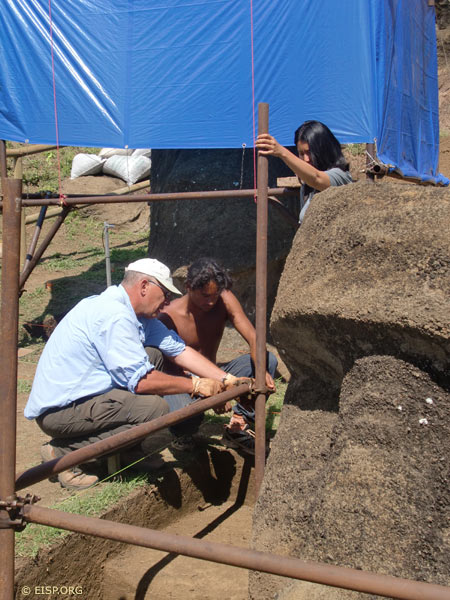
Lastly, a covered scaffold was raised to protect the statues from the elements and then to dry them out. In July, the on-going analysis of the data collected by the environmental monitoring equipment will be joined with an onsite evaluation of the stone surface condition. At that time, decisions will be made as to the first stage of the procedures planned to stabilize and consolidate and then protect the stone. Two more field seasons will result in the complete excavation and conservation of these two very important statues.
Epilogue Dated 27 April 2010: Vandalism
On 26 April 2010 in the morning hours just after the Rano Raraku security gate was opened, a group of Rapa Nui people vandalized the excavation site, destroyed some equipment and, most tragically, damaged Statue 158. Description of this incident is impossible at this time and it is being investigated by CONAF and island authorities. It appears to be an outgrowth of an on-going internal political conflict of long standing. We provided CONAF with all information requested, especially that describing statue condition. In the meantime, the conservation time table is being reconsidered. We will carry out our research plans in July and November in accordance with legal permits.
Acknowledgements
The Easter Island Statue Project (EISP; www.eisp.org) was founded by Jo Anne Van Tilburg, Ph.D. in 1982. It is an archaeological field survey and inventory conducted under permits issued by the Consejo de Monumentos Nacionales (CMN), Santiago de Chile, and with the cooperation of the Consejo de Monumentos Nacionales Rapa Nui and the Corporación Nacional Forestal (CONAF). Cristián Arévalo Pakarati has served as EISP graphic artist since 1989 and in 2002 became project co-Director. EISP maintains a permanent field office on Rapa Nui at the Mana Gallery, Petero Atamu s/n, Hanga Roa (www.managallery.org).
Mapping in Rano Raraku was accomplished during six seasons (2002-2007) with the assistance of Peter Boniface, Ph.D. (2002, 2003); Alice Hom (2002, 2004, 2006, 2007); Matthew Bates (2004, 2006, 2007); Bill White (2002, 2003, 2004); Debra Isaac (2002, 2004); Gordon Hull (2002); Alana Perlin (2003); Henry Debey (2006); Audrey Kopp (2007) and Jaine Manrique Sanchez (2007). Cristián Silva Araki and Susana Nahoe Arellano were project interns in 2003; Elena Mazuela Hucke assisted in 2004 and Johannes Van Tilburg in 2002 and 2007. Excavation was initiated by Van Tilburg and Arévalo Pakarati in 2010, with Alice Hom, Benjamin Mihaore Pakarati González, Patricio Rodrigo Madariaga, Carlos Rapu Rapu, and Johannes Van Tilburg. Alice Hom prepared the map illustrations.
The Easter Island Statue Project Conservation Initiative is implemented by Christian Fischer, Ph.D., Research Associate, The Cotsen Institute of Archaeology, University of California, Los Angeles (UCLA) and Mónica Bahamondez Prieto, Centro Nacional de Conservación y Restauración, Santiago de Chile. The EISP DATASHARE project team includes Alice Hom, Project Manager, Ewan Branda, Ph.D. candidate, Yoh Kawano, GIS Coordinator, UCLA Academic Technology Services, and Kim Anh Hoang. Funding is provided to EISP by the Site Preservation Initiative of the Archaeological Institute of America (AIA). Special thanks to the AIA Governing Board and especially to Larry Coben, Charles Steinmetz, and Charles Stanish, Director of the Cotsen Institute. Additional funding is provided by the Mana Foundation. Logistical support is provided by Gordon Hull and the staff of the UCLA Rock Art Archive and by Enrique Tucki, Pablo Hito and the staff of CONAF. Pedro Pablo Edmunds Paoa, Governor of Rapa Nui, articulates his visionary goals for Rapa Nui site conservation and graciously continues his long-standing interest in our project.