 English
  Español
 An introduction to Rapa Nui (Easter Island)
Easter Island: total land area of Rapa Nui
Reviewing the copious literature dealing with Easter Island, many conflicting figures for the land surface of the island are published. All of them are clearly inaccurate.
Given that many colleagues and interested people consult about this problem, we are now updating this information using the best available maps and techniques.
The surface of Easter Island was calculated based on air-photogrammetric digital mapping developed by IGM (Instituto Geográfico Militar de Chile), in August 2004, based on air photographs, scale 1:25.000, taken by SAF (Servicio Aerofotogramétrico de la Fuerza Aérea de Chile) in 1981.
For the vectorial cartography, the Geodetic Reference System SIRGAS(WGS84) in UTM projection zone 12 (central meridian 111°W) were used, designed for graphic plots to scale 1:10.000, with contour lines every 5 meters.
Our calculations show that the exact value of the area included by the projected coastal polygon of Easter Island is of 16,357.4026 hectares and, after applying the reciprocal square of the UTM mean scale factor for the island, a corrected value of 16,359.7354 hectares or 40,425.6209 acres is obtained, as effective for the zero contour at mean sea level.
Thus, the surface of Easter Island rounded to the nearest decimal, is of 163,6 square kilometres or 63,2 square miles.
Claudio Cristino and Roberto Izaurieta
10 June 2005
Facts About Rapa Nui (Easter Island)
Location
Lying isolated in the East Pacific, in an extreme windward position, Rapa Nui is the easternmost Polynesian island. It is in the Southern Hemisphere at 27° 9’ S latitude, 109° 26’ W longitude. Situated on the Nazca Plate at a volcanic and tectonic “hot spot,” it is 3703 km west of South America and 1819 km east of Pitcairn island. The total land area is 163.6 sq km or 63.2 sq mi.
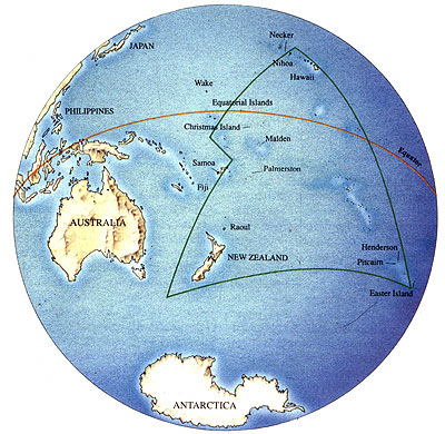
Map showing the location of Rapa Nui (Easter Island) within the Pacific Ocean and the Polynesian triangle.
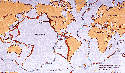
Map showing the Nazca Plate, on which Rapa Nui (Easter Island) is located.